Build your hike with a fingertip, see the climb before you climb it, and keep the map when the signal drops. For a first time at Col des Bœufs as much as for the thirtieth.
141.9 kmof waymarked trails in Mafate. Premium unlocks all of Réunion
To the metreelevation computed from IGN survey data
Zero barsof signal needed once you set off
↓
Map downloadedMafate · 62 MB
Sentier ScoutClosed: you know before you go
StartCol des Bœufs · 1,960 m · scroll to start walking
Planning your hike
Say where you want to go, the app handles the rest
For people discovering the cirque and for people who know it by heart: 5 a.m. starts, dead zones, trails that close overnight.
Your route, at your pace
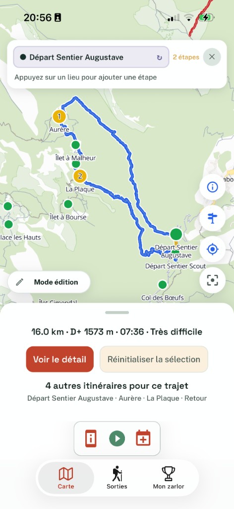
A start, a finish, the hamlets in between: distance, ascent, descent, difficulty and duration appear straight away — computed from your pace, not from an average.
Elevation from IGN survey data, not a worldwide estimate
Changed your mind in the car park? Everything recomputes, offline
Closures and weather, before you leave
When the ONF closes a trail or Météo-France raises an alert, you hear about it in the app and by notification. If your route goes through it, it is flagged.
The alert is about your route, not a list to sift through
Notified as soon as the order is published
No idea where to go? Let the app suggest
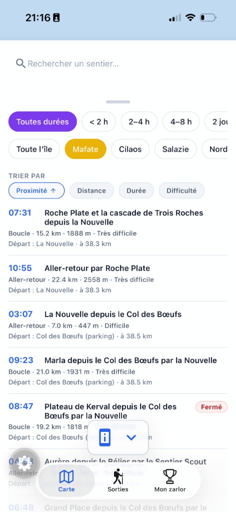
Two hours or three days? The app proposes loops and crossings based on the part of the island, the time you have, and what you can actually climb.
Filters by region, duration and difficulty — no jargon
Lodges and guest tables readable offline
The map
The whole island, trail by trail
Tap a hamlet, a pass, a waterfall: it becomes a waypoint. Distance, elevation and duration follow every tap.
Read in the middle of your route and turned into walking conditions: what it means underfoot, not a column of numbers.
From Mafate to all of Réunion
Premium
Download once, keep the map and its points of interest. Your Garmin or Komoot tracks import, yours export.
Relive the hike in pictures
The route unrolls over satellite imagery, profile and photos alongside — ready to send to whoever missed it.
Lodges and guest tables
Every hamlet has its sheet, readable from the map even offline, with the lodge's number one tap away.
GPX import / export
Premium
Open a friend's track, snap it back onto the waymarked trails, leave with your own.
Your people
The people who care know where you are
You invite once. At every departure and every arrival, they are notified by email or push, with nothing to install — they follow the hike on a plain web page.
No false alarms
The app tells apart “no signal”, “flat battery”, “hike finished” and genuine trouble. A dot that stopped moving is never presented as a drama.
If you are not back
Arrival time passed and still no news: your people get a notification. Nothing for you to trigger.
iOS Live Activity and widget
Premium
Your progress shows on their lock screen, with your mascot. Low-power mode measured at around 4% battery per hour.
Community
Share what you saw out there
24 h
Word from the walkers ahead
Muddy stretch, ravine in flood, trail cut: the people who passed before you leave the information at the exact spot. Published with a five-minute delay, moderated, erased after 24 hours.
Nothing is kept: neither the messages nor the positions
Loaded once, readable offline
My zarlor
Every point of interest you pass in the field joins your collection: pools, passes, viewpoints. The network already walked, about twenty achievements with Creole names, a character to grow.
Premiumthe RandoMafateur cap
Your hiking logbook
Every hike leaves a recap to send as a link: the track, the numbers, the photos — and heart rate if you wear a watch.
Devices and languages
Everyone walks their own way
In your language
The app follows your phone's language: for walking here, and for planning the trip from the other side of the world.
Map styles and themes
Premium
Satellite, relief, or maximum legibility depending on what you are trying to see — and the interface in light or dark.
Apple Watch and Wear OS
Soon
Track, pace and heart rate on the wrist, without taking the phone out of the bag. Everything resyncs on return. In testing on real devices.
What the subscription adds
The trails of the whole island, live tracking for your people, GPX import / export, map styles and the RandoMafateur cap. Mafate, routing, closures, lodges and zarlor stay free.
Choosing the trail, finding a lodge, checking that nothing was closed along the way, looking up the weather on the right side of the mountain… The hike was beautiful. Getting ready for it, much less.
I started by gathering it all in one place, for myself. Then I added whatever I was missing on the next outing: offline maps, real walking times, routing from one point to another. Today every feature in RandoMafate answers a problem met in the field, not a box to tick.
One developerfrom the trail to the release
Based on Réunion Islandthe trails are next door
Your feedback countsit ships to production
I am a developer from Réunion, I build the app on my own, and I am the one who reads the mail. A trail, a piece of information, a feature missing? Write to me at contact@randomafate.app.
They walk with it
From the people who actually climb
★★★★★
“Très pratique dans Mafate !”
CCatholebApp Store
★★★★★
“First time in Mafate, I had never known how to read an elevation profile. Seeing the climb before doing it stopped me setting off on something too hard for me.”
LMLéa M.Saint-Denis
★★★★★
“We climb as a group of eight, at very different paces. Seeing everyone on the map cut the twenty-minute waits at every junction.”
TRThierry R.Mountain guide, Salazie
★★★★★
“Hike planned from Nantes, the lodge at Aurère called straight from its sheet. On site, not a bar of signal and yet everything was there.”
NPNaïma P.Nantes → Le Port
Finish
Ready for the next start?
Free, and no account needed to explore the map. Download RandoMafate, tell the people who care, go walk.